Can Colorado get back to normal snowpack conditions this winter?
History shows it’s possible, but forecasts aren’t promising

Chris Dillmann/Vail Daily archive
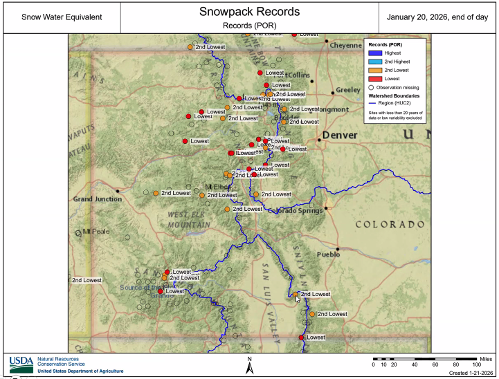
Colorado’s snowpack has hit record lows across the state this winter.
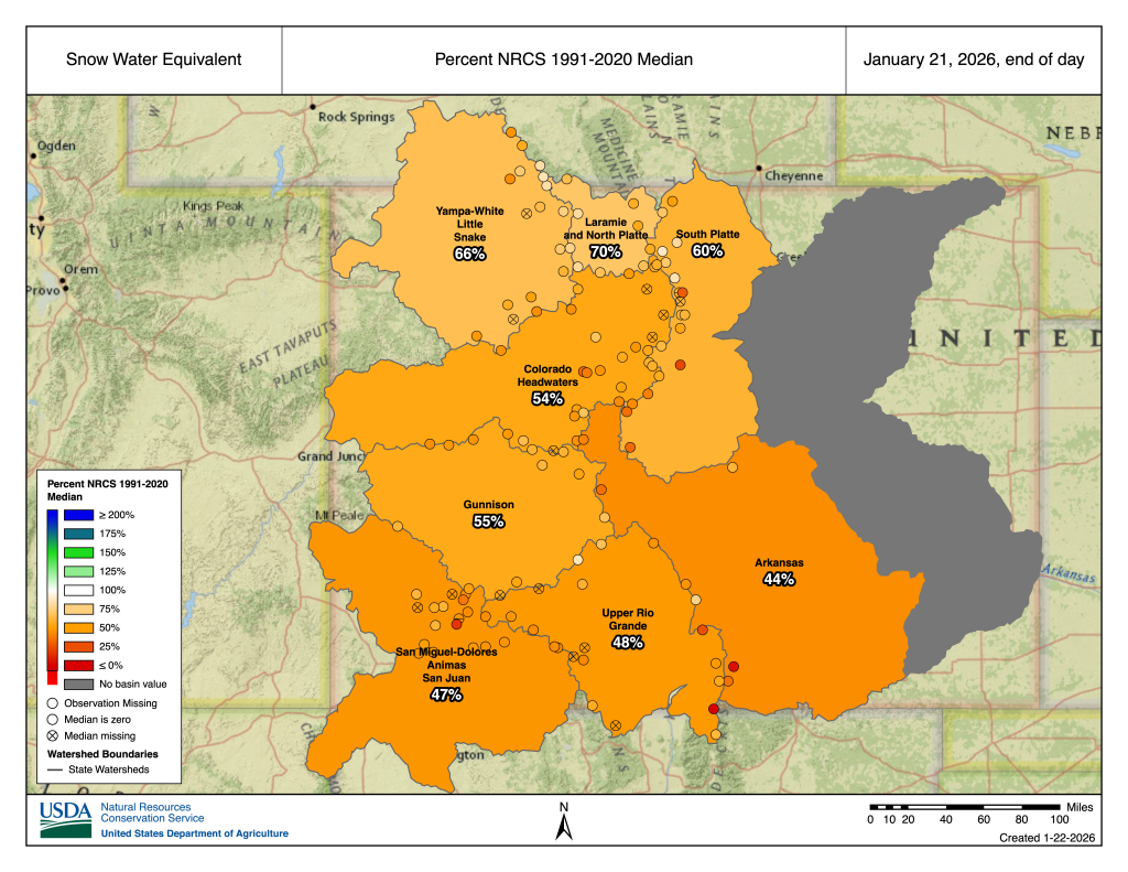
During a Jan. 22 Water Conditions Monitoring Committee, Brian Domonkos, the Colorado snow survey supervisor for the U.S. Natural Resources Conservation Service, reported that the best snowpack conditions in Colorado, in the Rio Grande basin, still rank as the fourth worst in the last 40 years on record.
Statewide snowpack and snowpack in the Colorado River Headwaters basin are both at record lows for the period on record, Domonkos reported.
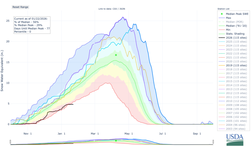
“At this point in the year, we are 51% of the way through the winter or the snowpack accumulation season,” Domonkos said. “There’s a very, very small chance that we could get back to normal at this point.”
Colorado’s mountain snowpack acts as a natural reservoir, providing the vast majority of the state’s water supply for municipal use, agriculture, recreation and more.
Support Local Journalism
“We have 4.8 inches of water content on average across all of our snow measuring sites in Colorado,” Domonkos said. “Typically, at this point in the year, we have about 8.5 inches of water content (in the snowpack).”
While it’s a bit early to look at predictions for the spring runoff, “it’s very likely that we’ll wind up seeing below normal runoff projections this year,” Domonkos said.
For Colorado to end the winter with a normal amount of snowpack, the state “needs about 145% of normal snow accumulation,” he said, adding that this is “close to needing the maximum amount of snow accumulation that we’ve ever seen in the last 40 years in order to get back to normal.”
“It is something that would be nice to have from a water standpoint, looking through the remainder of year and into the water supply season in the spring and summer,” Domonkos said, adding that on the other hand, receiving that much snow in a short amount of time could bring greater avalanche concerns as well as challenges for snow removal and measurement operations.
While unlikely, it is not unheard of.
Domonkos said that in the last 40 years, “there were three years in which we accumulated as much snow as we would need to get back to normal,” during the second half of the winter season. This includes 1993, 1995 and 2019.
“What is interesting about these three years is they were all near or above normal at this point, before they really took off and wound up seeing a significantly increased amount of precipitation and snowpack accumulation,” he said. “This, in my opinion, fortifies the fact that it’s going to be quite difficult to get back to normal.”
Getting back to normal would require a significant shift in the weather patterns Colorado has experienced since the start of the 2026 water year on Oct. 1.
The first three months of the water year saw record warm temperatures and drier than normal conditions, culminating in a “disturbingly warm” December that hit records on the Western Slope, according to Allie Mazurek, the engagement climatologist at the Colorado Climate Center at Thursday’s meeting. January has continued the trend toward warmer and drier conditions, she added.
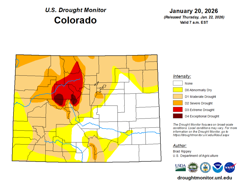
December’s warm temperatures saw a return of exceptional drought — the most extreme rating on the U.S. Drought Monitor — in central Colorado, including portions of Eagle, Pitkin, Park, Lake and Summit counties. Around 16% of the state is experiencing severe or worse drought conditions, according to the latest Jan. 22 drought monitor, Mazurek reported.
The current conditions follow immediately after a water year where “snowpack wasn’t that great,” Domonkos added.
“It wasn’t as bad as it is now, but we were still looking at a dry winter,” he said. “In 2025, snowpack just didn’t measure up and melted out pretty early.”
At the end of the 2025 water year, Colorado was at 87% of normal precipitation statewide, meaning it received 13% less precipitation than normal.
It was also the fourth-hottest water year in the last 131 years on record in Colorado, following a larger trend with climate change, Mazurek said.
“We’ve seen this rapid increase in warming temperatures since 2000 or so,” she said. “Notably, with the fourth hottest year on record occurring in 2025, eight of the 10 warmest years on record have occurred since 2012, so quite remarkable warmth that we’ve seen over the last decade and a half in Colorado.”
While Domonkos reported that Colorado needs a “significantly greater change in the weather patterns,” the forecasts aren’t promising.
“After this weekend, our next chances for precipitation do not look to be likely until at least early February, maybe longer,” Mazurek said, adding that there are “slightly better chances in our mountain areas.”
The U.S. Climate Prediction Center’s 8-14 day outlook shows “not great news” with warmer and drier than normal conditions expected in the western United States, including Colorado, Mazurek said.
Mazurek added that between February and April, there is “fairly high confidence” that Colorado will see a shift from La Nina to neutral conditions, which carries uncertainty and makes predicting precipitation “even more difficult,” as there is “little known connection” between neutral conditions and Colorado precipitation.