Gore Creek peaks in July for the first time in Vail recording station’s history
After two false summits, Vail waterway peaks again — 26 days later than usual


Eagle River Water and Sanitation District
In Vail, after seeing Gore Creek peak on June 19, crews were called off their nightly flood monitoring duties for the start of summer.
They were called back on the weekend of June 29-30, however, and for good reason. After seeing two false summits on Gore Creek’s graph this year, another peak was coming — and this one would be the biggest since 2010, and the third biggest in the 19 years flows have been recorded at the Eagle River Water & Sanitation District’s Vail facility. The measuring station is just above Red Sandstone Creek near Lionshead.
The Vail Fire Department prepared properties in the Intermountain neighborhood with sandbags and workers closed Bridge Road in East Vail during the night as Gore Creek topped the bridge. The creek had also hit the walking path that runs along it in Vail Village behind the Mountain Haus hotel, and that path was closed.
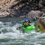
By the end of the night, flows had hit more than 2,000 cubic feet per second on the west end of Lionshead Village, a rare occurrence. It is even more rare for June 30, considering the average daily flow at peak runoff is about 800 cfs and occurs about June 5.
On July 1, the average daily flow on Gore Creek above Red Sandstone was 1,580 cfs, a new record for July 1 and the first time a July peak had ever been recorded at the Eagle River Water & Sanitation District’s Vail recording station.
Support Local Journalism
Deluge rain events
The afternoon and evening deluges of rain that fell this past weekend are largely to blame for the unusually high flows. That and the fact that the snowpack, which received a refresh of snow the weekend of June 22-23, is still strong at higher elevations.
Sunday’s steady showers in Vail throughout the evening were much more intense than a typical afternoon rain event in the high country.
“We had that really hot weather. We’re finally getting the melt of all that snow, and right when streams would have been getting much higher anyway from that snowmelt cycle, we then get all that rain at five o’clock, and on into the evening, that just added a ton,” said Diane Johnson, of the Eagle River Water & Sanitation District.
Johnson has been monitoring flows on the Eagle River and Gore Creek, and said when the graphs near Vail reached what looked like a summit on June 19, she was fairly confident in declaring that the peak.
A first false summit in the graph had materialized around June 14, when flows near the wastewater plant in Vail had reached an average daily mean of 1,120 cfs and then started dipping back down. By June 19, the recording station was back up to an average daily mean of 1,200.
“I felt pretty comfortable about June 19 (representing the peak), but then after the 19th, we got all that snow,” Johnson said. “It’s been a crazy year, for sure.”
More rain possible
With two false summits on the graph, all predictions are now out the window, but this year’s July 1 average daily mean of 1,580 cfs is way off the charts for what is normal.
The daily mean is the average of all of a day’s readings, which take place over 15-minute time periods. It’s rare to see a single reading jump over 2,000 cfs at any point throughout the day, and to have it happen on June 30 is extremely unusual.

John LaConte | jlaconte@vaildaily.com
On June 6, 2010, the Vail station above Red Sandstone measured 2,260 cfs at 9:45 p.m. The next individual record after that occurred on Sunday, when that same station recorded 2,150 cfs at 10 p.m.
And afternoon rain deluges could continue on Tuesday and Wednesday, said Meteorologist Kris Sanders with the National Weather Service in Grand Junction.
“It’s really hard to predict exactly where and how much can come out of some of these storms, because they’re so isolated in nature,” he said. “But those chances aren’t as high, and we’re going into a dryer pattern, at the end of the week. So it will at least allow some of the water flow to slow down.”