Colorado activates drought task force as hope for snowpack recovery dwindles
With a heat wave on the way, climate experts wonder whether snowpack has already peaked in the High Country

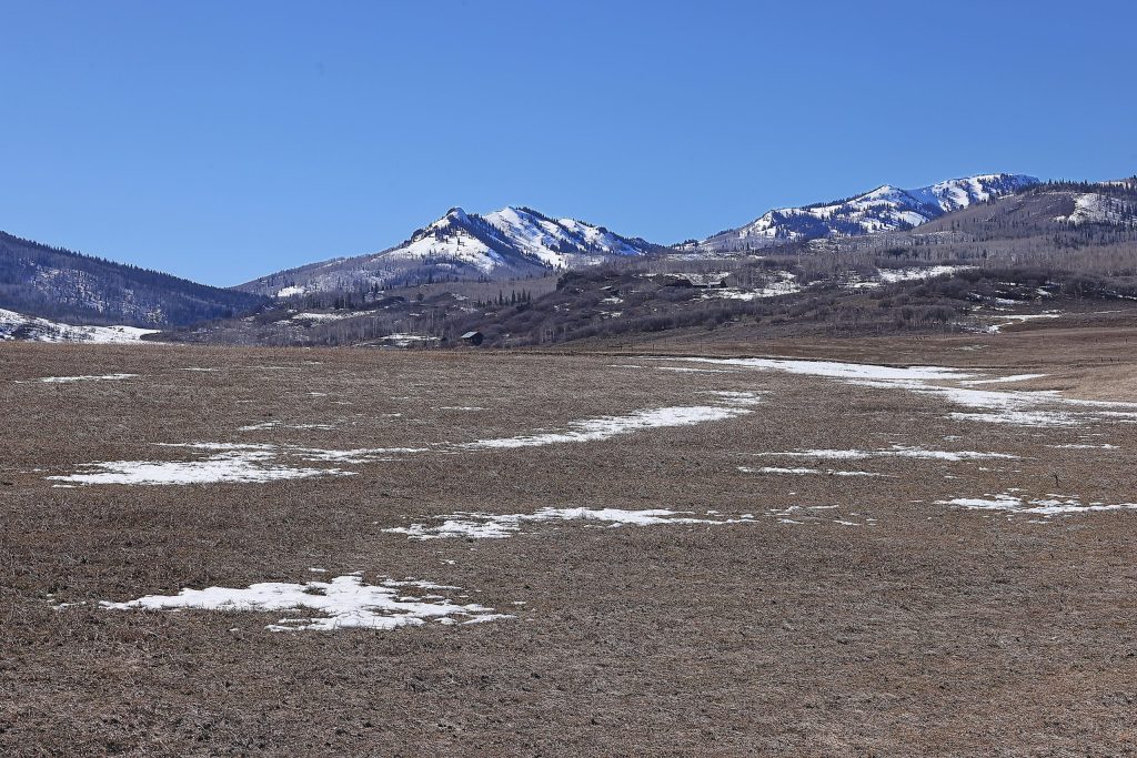
John F. Russell/Steamboat Pilot & Today archive
Colorado Gov. Jared Polis activated the state’s Drought Task Force on Tuesday, March 17, as current conditions and future forecasts paint a grim picture.
“Colorado is experiencing the warmest year so far in our 131-year record, and one of the driest,” Polis said in a news release. “Activating the Drought Task Force will help ensure we are protecting one of our most precious resources by closely tracking impacts, supporting communities and coordinating better as we prepare for the year ahead.”
Given these historic conditions, the March activation this year marks an earlier-than-normal response as the state prepares for what Nate Pearson, the assistant director for water policy for Colorado’s Department of Natural Resources, said is “going to be a really challenging year,” at the Colorado Water Conditions Monitoring Committee meeting on Tuesday.
The task force is a key part of Colorado’s Drought Mitigation and Response Plan, which was most recently activated in June 2020 and maintained throughout the 2020-21 drought. Before that, the state’s drought response and task force was fully activated in late April 2002 for the first time since the plan’s creation in 1981.
The task force pulls together state agencies to monitor drought conditions, provide a coordinated response to agriculture, municipal water supplies, wildlife and recreation impacts, recommend emergency actions and declarations, facilitate allocation of resources and improve public communication. Coordination includes the Colorado Water Conditions Monitoring Committee and the Colorado departments of natural resources, agriculture and local affairs, as well as the divisions of water resources and homeland security and emergency management.
Support Local Journalism
In a statement, Lauren Ris, Colorado Water Conservation Board director, said it will help “the state understand where impacts are being felt the most, and elevate those local challenges so we can better coordinate response and support communities across Colorado.”
Drought deepens across Colorado

The latest Colorado Drought Monitor, published on March 12, shows 80% of the state is experiencing some kind of drought conditions, according to Peter Goble, the assistant state climatologist at the Colorado Climate Center, at the committee’s meeting. Around 64% of the state is facing moderate or worse drought conditions and 37% suffering from severe to exceptional drought. The worst conditions are in portions of Summit, Lake, Eagle, Pitkin and Park counties.
These conditions represent a significant degradation from a year ago, particularly in northwest and north-central Colorado, where a hot, dry summer led into a winter with historically low snowpack and record-breaking warm temperatures, Goble said.
February ranked as the warmest on record, with statewide temperatures hitting 7.8 degrees above the average temperatures from 1991 to 2020.
“If we were just looking at a day or two of data, 7.6 degrees above normal wouldn’t be that big a deal, but if you’re averaging over the course of a whole month, that’s a pretty huge anomaly,” Goble said.
This also follows several months of consistently warmer-than-normal temperatures — January ranking as the 17th warmest on record, December as the No. 1 warmest, November the third warmest and the 11th warmest October — and is a trend expected to continue, according to Goble.

“We have continued the streak of above-normal temperature conditions, with most of the state, over 6 degrees warmer than normal for the first half of March,” he said. “That is likely to continue, maybe even intensify, over the coming couple of weeks.”
This week, Colorado mountain towns are expected to see temperatures of up to 25 degrees higher than normal. Goble referred to it as a “historic heat wave or warm wave” that is especially alarming given the current state of snow in the High Country.
Has snowpack already peaked in the High Country?
With this forecast and snowpack already historically low, Goble said, “it’s possible that many areas of the state, at high elevations, have already seen peak snowpack.”
“That doesn’t mean that the moisture that we get later in the spring won’t be important,” he said. “Moisture that we get in April and May, and even into June, will still be crucial for our water supply, but it’s possible that the very meager snowpack numbers … could be as high as they get for this year.”
Brian Domonkos, a Colorado hydrologist with the Natural Resources Conservation Service, agreed with Goble’s assessment, adding that while it’s possible — and not unheard of — that Colorado could see some recovery of snowpack, it’s extremely unlikely at this point.

“The entire state of Colorado is very poor for snowpack. There’s no basin that is looking good,” Domonkos said. Both the Colorado River headwaters and Yampa/White River basins in northwest Colorado are experiencing their lowest snowpacks on record.
Snowpack typically peaks around April 7, with Colorado receiving around 13% of its annual snowpack from now until the peak, Domonkos said.
“Point being, we have very little winter left,” he added. “There’s essentially no chance for us to get back to normal snowpack. The question is: Will we get back to the minimum snow pack that we’ve seen in 2002, 2018 or 2012,” listing other low snowpack years.
In 1981 — currently ranked as the state’s worst snowpack year — March brought a change in weather, receiving 140% of normal snowpack from March 1 to the middle of April, Domonkos said.
“So, it is possible, but it doesn’t look very likely based on the forecast model runs that I was looking at this morning, and the seasonal and shorter-term outbooks,” he said. “My guess is … at least in the next week or two, and we will probably surpass 1981 as the lowest year by somewhere around the 20th, 21st or 22nd (of March), depending on how things go.”
This forecast also means that the streamflow forecasts will continue to see downturns, Domonkos added.
A bright spot watching for El Nino?
In looking for a single bright spot, Goble said there is an El Nino watch heading into late summer.
“For most seasons, it tends to be better for us (with regard to moisture) if we have El Nino conditions, but it’s not a guarantee,” he said, adding that looking at this summer, it could bring an active monsoon season to western Colorado.
“Some of these models are showing a better-than-normal shot of an active monsoon this summer,” he said. “So maybe a little bit of hope there, but based on the three-month outlook, and especially based on the more near-term outlook, I think that it’s likely that things get worse before they get better.”
Colorado has been in La Nina conditions this winter, with some weather models showing it dead or “hanging on by a thread” at this point in the year, Goble said.
The challenge with La Nina and El Nino predictions is that it’s like a game of poker, he added.
“You have an idea of how the deck is stacked, but it doesn’t tell you what hand you’ll get. You can have the deck stacked in your favor and still draw a crummy hand, and that’s kind of what we saw in the Northern Rockies this winter,” Goble said, referring to the fact that, typically in La Nina winters, the Northern Rockies tend to see above normal precipitation.
“But we had La Niña in place this winter, and it turned out to be a total bust,” he added.