Update: Derby Fire surpasses 4,000 acres; Colorado River Road closure extended
More crews are joining the effort as Derby Fire is the No. 1 fire in the nation in regards to needing resources

Eric White/Derby Fire Facebook Page
This story was updated at 8 p.m. with updated road closure information, weather information and acreage.
As local and federal officials gathered Friday night in Gypsum to provide an update to displaced residents and the greater community on the nearby Derby Fire, rain started falling outside.
It was a welcome sign in a week where hot, dry weather and nightly winds have fueled the growth of the wildfire burning in northwest Eagle County to more than 4,112 acres, an area encompassing more than 6 square miles.
The probability of wetting rain — more than 1/10 of an inch — falling on the fire is going up entering the weekend, with the chance of wetting rain jumping from 5% Saturday to 8% Sunday to 40% on Monday and hovering above 25% through Thursday.
The Derby Fire has burned 4,112 acres and remains 0% contained as of 8 p.m. Friday, according to the National Interagency Fire Center.

Support Local Journalism
A closure of Colorado River Road was extended Friday evening all the way south to the roundabout in Dotsero. The closure runs through Red Dirt Creek Road southwest of Burns. Eagle County Sheriff James van Beek said he extended the closure out of an abundance of caution for fire crews in the area and residents.
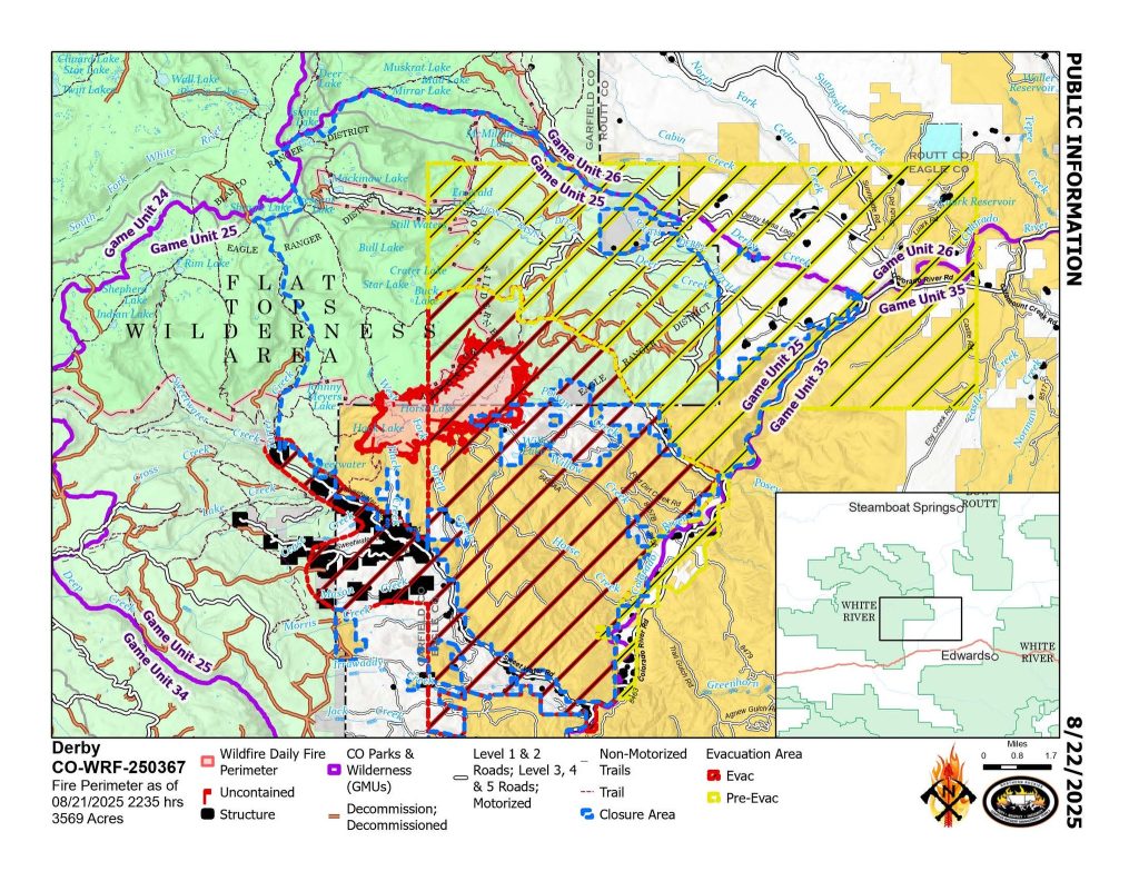
Areas along the Colorado River Road have been moved to pre-evacuation status. Anyone who will take longer to evacuate, such as those with pets or livestock, should leave now.
Helicopter pilot OK after crash
A helicopter pilot assigned to the Derby Fire is OK after a crash on Friday near the Eagle County airport, according to the U.S. Forest Service.
There is an unconfirmed report that the helicopter is in a lake 13 miles northwest of the airport, according to the Forest Service’s release on the incident. The pilot was picked up by another aircraft and flown to the airport. Local emergency medical personnel checked the pilot, who had minor bumps and bruises and desired no further medical attention.
The National Transportation Safety Board has been notified of the incident, but it is unknown whether it will respond. The Forest Service said A USDA Forest Service investigation team is on its way to Eagle County to investigate.
There are 211 personnel working the fire, including three helicopters, four dozers and nine hand crews, according to the National Interagency Fire Center.
While resources are requested and managed by the Northern Rockies Complex Incident Management Team 3, local crews from Eagle River Fire Protection District, Vail Fire Department and Eagle Valley Wildland are assisting with the firefighting effort.
No. 1 fire in the country
The Derby Fire is the top priority fire in the country for needing resources, according to public information officer Stefani Spencer, partially due to the fire’s proximity to communities and its growth pattern.
“They also look at the probability of success,” Spencer said of the national ranking system. “If we get these, how probable are we to have success in meeting the objective, which is to protect public land.”
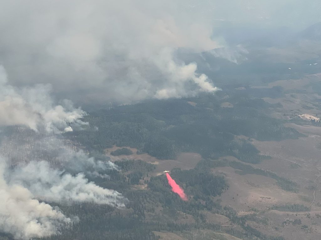
Operations have heavilly focused on the southern edge of the lightning-caused fire, with “heavy air presence” dropping water and applying retardant, said Philip Knaub, operations section chief, in a morning update.
Planes have been pulling water from various ponds across the area. The incident management team is working with local authorities to avoid any cross-contamination between bodies of water, which is a concern since the source of zebra mussels in Colorado was determined to be in Eagle County.
“If they do have to go from a contaminated area to a non-contaminated area, they have to go to the helibase and have their equipment sterilised,” Spencer said.
The main focus of Friday’s operations were the southwest corner of the fire closest to Sweetwater, as well as the eastern edge of the blaze, Knaub said in the morning report.
More resources are en route as well, including engines and hotshot crews, all of which will be focusing on the Sweetwater Lake section of the fire. As other fires across the state wind down, resources have been reallocated to the Derby Fire.
There are 459 structures identified as threatened based on a model that predicts worst-case scenario fire spread. Most of those structures are homes in the Sweetwater Canyon area, as well as along Colorado River Road and ranches spread across the Derby Mesa area.
One structure was destroyed earlier in the week, a hunting cabin that did not serve as a primary home.
Weather and fire behavior outlook
The good news is the chance of showers, as well as cloud cover that improves humidity and keeps temperatures lower. The bad news is that as the chance of rain rises, so do the odds of lightning and gusty winds.
Into and beyond the weekend, crews expect the chance of rain to increase. However, the chance for lightning and outflow winds from passing storms will increase as well, according to an evening update posted on the Derby Fire Facebook page Thursday night.
Evacuations and closures
Residents in the area of Sweetwater Lake were asked to evacuate by noon Wednesday, and about 200 to 400 residents have had to leave their homes, said Birch Barron, Eagle County’s emergency management director.
Evacuation resources were moved from an in-person center to remote and can be accessed by calling 970-328-7400.
Evacuation resources include support with shelter for displaced residents, along with clothes, food, behavioral health support and support with animals and agriculture.
The U.S. Forest Service and Bureau of Land Management have both issued closures in the fire area as well.
The Forest Service closure is within the Blanco and Eagle-Holy Cross Ranger Districts, starting north of Sweetwater Lake, following the forest boundary north and east to the intersection of the Derby Loop Road (Eagle County Road 39); following Middle Derby Creek generally northwest to Island Lakes; then, generally south following the Island Lakes Trail (#1842), the W Mountain Trail (#1817), the Turret-Crescent Trail (#2269) and the Turret Creek Trail (#1838) back to Sweetwater Lake.
This closure affects BLM lands north and west of the town of Gypsum that are north of Coffee Pot Road; west of the Colorado River; east of the White River National Forest boundary; and south of Derby Creek.
Resources related to the Derby Fire can be found on ECEmergency.org.
Shelby Valicenti and Zoe Goldstein contributed reporting.